
Make a donation
Gear up for your next adventure:
As an Amazon Associate, this site earns from qualifying purchases at no extra cost to you.
Piedrafita de Jaca topographic map
Click on the map to display elevation.
Make a donation
Gear up for your next adventure:
As an Amazon Associate, this site earns from qualifying purchases at no extra cost to you.
About this map
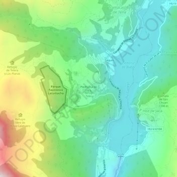
Name: Piedrafita de Jaca topographic map, elevation, terrain.
Average elevation: 1,321 m
Minimum elevation: 1,000 m
Maximum elevation: 2,074 m
Make a donation
Gear up for your next adventure:
As an Amazon Associate, this site earns from qualifying purchases at no extra cost to you.
Other topographic maps
Click on a map to view its topography, its elevation and its terrain.
Biescas
Spain > Aragon > Alto Gállego
The town of Biescas is located at 875 meters altitude on the banks of the Gállego river. The municipality extends along a small plain and includes the canyon to access to the Tena Valley. At 72 km north of the main city Huesca, Biescas is a communication hub between the regions of Jacetania and Sobrarbe. The…
Average elevation: 1,472 m
Make a donation
Gear up for your next adventure:
As an Amazon Associate, this site earns from qualifying purchases at no extra cost to you.