Geolocate

Panticosa topographic map

Click on the map to display elevation.

About this map

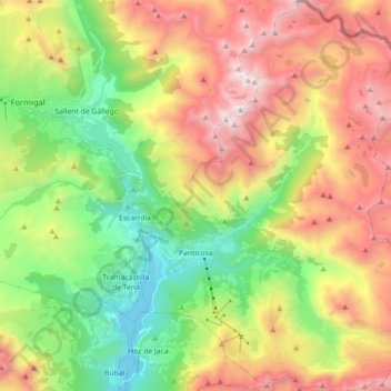
Name: Panticosa topographic map, elevation, terrain.

Location: Panticosa, Alto Gállego, Huesca, Aragon, Spain (42.67740 -0.31389 42.80819 -0.17787)

Average elevation: 1,916 m

Minimum elevation: 1,050 m

Maximum elevation: 3,059 m

Other topographic maps

Click on a map to view its topography, its elevation and its terrain.

Valle de Tena

Spain > Aragon > Alto Gállego > Búbal

Average elevation: 1,313 m

Lárrede

Spain > Aragon > Alto Gállego > Sabiñánigo

Average elevation: 957 m

Pico Anayet

Spain > Aragon > Alto Gállego > Sallent de Gállego

Average elevation: 2,176 m

Peña Telera

Spain > Aragon > Alto Gállego > Biescas

Average elevation: 2,130 m

Piedrafita de Jaca

Spain > Aragon > Alto Gállego

Average elevation: 1,321 m

Gear up for your next adventure:

🥾Waterproof Hiking Boots - Essential footwear for rugged terrain and wet Canadian trails
📷Outdoor Action Camera - Capture high-elevation views and rugged adventures
🛁Quick-Dry Microfiber Towel - Space-saving towel that dries rapidly on the move
🧤Insulated Winter Gloves - Heavy-duty protection for sub-zero Canadian adventures
🥾Mountain Hiking Shoes - Shoes with superior grip for mountainous terrain

As an Amazon Associate, this site earns from qualifying purchases at no extra cost to you.