
Aying topographic map
Click on the map to display elevation.
Aying
Aying wird von sechs Gemeinden Brunnthal, Egmating (Kreis Ebersberg), Feldkirchen-Westerham (Kreis Rosenheim), Glonn (Kreis Ebersberg), Höhenkirchen-Siegertsbrunn und Valley (Kreis Miesbach) umgeben.
About this map
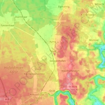
Name: Aying topographic map, elevation, terrain.
Location: Aying, Landkreis München, Bayern, Deutschland (47.91593 11.70497 48.00339 11.85209)
Average elevation: 621 m
Minimum elevation: 549 m
Maximum elevation: 683 m
Other topographic maps
Click on a map to view its topography, its elevation and its terrain.
Beigarten
Deutschland > Bayern > Landkreis München > Straßlach-Dingharting > Beigarten
Average elevation: 625 m
Deisenhofen
Deutschland > Bayern > Landkreis München > Oberhaching
Das Pfarrdorf liegt direkt südlich des Ortsteils Oberhaching am Nordende des Gleißentals auf einer Höhe von 595 m. In dem Ort tritt das durch das Gleißental fließende Grundwasser zutage und bildet den Hachinger Bach.
Average elevation: 592 m
Hailafing
Deutschland > Bayern > Landkreis München
Beigarten | Deigstetten | Ebertshausen | Epolding | Frundsbergerhöhe | Gleißentalweiher | Großdingharting | Hailafing | Holzhausen | Kirchlberg | Kleindingharting | Mühlthal | Straßlach
Average elevation: 637 m
Steinkirchen
Deutschland > Bayern > Landkreis München > Planegg > Martinsried
Average elevation: 549 m
Unterschleißheim
Deutschland > Bayern > Landkreis München > Unterschleißheim
Aschheim | Aying | Baierbrunn | Brunnthal | Feldkirchen | Gräfelfing | Grasbrunn | Grünwald | Hohenbrunn | Höhenkirchen-Siegertsbrunn | Ismaning | Kirchheim bei München | Neubiberg | Neuried | Oberhaching | Oberschleißheim | Ottobrunn | Planegg | Pullach im Isartal | Putzbrunn | Sauerlach | Schäftlarn |…
Average elevation: 477 m
Haar
Deutschland > Bayern > Landkreis München > Haar > Haar
Das Haarer Trinkwasser wurde zunächst in Brunnen am Rande des Gemeindegebietes gefördert. Um die Versorgung des wachsenden Ortes auch für die Zukunft langfristig zu sichern, wurden neue Quellen erschlossen. So stammt seit 2011 das geförderte Wasser aus einem Gebiet im Höhenkirchener Forst, in dem das…
Average elevation: 543 m