
Colina topographic map
Click on the map to display elevation.
About this map
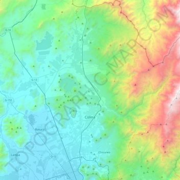
Name: Colina topographic map, elevation, terrain.
Average elevation: 1,130 m
Minimum elevation: 474 m
Maximum elevation: 3,445 m
Other topographic maps
Click on a map to view its topography, its elevation and its terrain.
Estación Colina
Chile > Región Metropolitana de Santiago > Provincia de Chacabuco
Average elevation: 495 m
Lo Arcaya
Chile > Región Metropolitana de Santiago > Provincia de Chacabuco > Colina
Average elevation: 551 m
Quilapilún Alto
Chile > Región Metropolitana de Santiago > Provincia de Chacabuco > Colina
Average elevation: 749 m
Los Cántaros
Chile > Región Metropolitana de Santiago > Provincia de Chacabuco > Batuco
Average elevation: 493 m
Rincón de Los Valles
Chile > Región Metropolitana de Santiago > Provincia de Chacabuco > Tiltil
Average elevation: 1,160 m
Chamisero
Chile > Región Metropolitana de Santiago > Provincia de Chacabuco > Colina
Average elevation: 699 m
Laguna Piedra Roja
Chile > Región Metropolitana de Santiago > Provincia de Chacabuco > Colina > Chicureo
Average elevation: 626 m
Chicureo
Chile > Región Metropolitana de Santiago > Provincia de Chacabuco > Colina
Average elevation: 711 m
San José
Chile > Región Metropolitana de Santiago > Provincia de Chacabuco > Colina > Lo Arcaya
Average elevation: 537 m
Santa Ester Oriente
Chile > Región Metropolitana de Santiago > Provincia de Chacabuco > Colina
Average elevation: 539 m
Canal El Carmen
Chile > Región Metropolitana de Santiago > Provincia de Chacabuco > Colina > Los Jardines de Colina
Average elevation: 533 m
El Colorado
Chile > Región Metropolitana de Santiago > Provincia de Chacabuco > Colina
Average elevation: 643 m
El Manzano
Chile > Región Metropolitana de Santiago > Provincia de Chacabuco > Colina
Average elevation: 814 m
Peldehue
Chile > Región Metropolitana de Santiago > Provincia de Chacabuco > Colina
Average elevation: 743 m
Santa Carolina Poniente
Chile > Región Metropolitana de Santiago > Provincia de Chacabuco > Batuco
Average elevation: 490 m
Chacabuco
Chile > Región Metropolitana de Santiago > Provincia de Chacabuco > Colina
Average elevation: 730 m
Talavera
Chile > Región Metropolitana de Santiago > Provincia de Chacabuco > Colina > Chacabuco
Average elevation: 729 m
Rungue
Chile > Región Metropolitana de Santiago > Provincia de Chacabuco > Tiltil
Average elevation: 784 m
Polpaico
Chile > Región Metropolitana de Santiago > Provincia de Chacabuco > Tiltil
Average elevation: 568 m
Hacienda El Sol
Chile > Región Metropolitana de Santiago > Provincia de Chacabuco > Sol de Septiembre
Average elevation: 486 m
Tunquelén
Chile > Región Metropolitana de Santiago > Provincia de Chacabuco > Lampa > Tunquelén
Average elevation: 506 m
Valle de Luna
Chile > Región Metropolitana de Santiago > Provincia de Chacabuco > Lampa
Average elevation: 609 m
Chicureo
Chile > Región Metropolitana de Santiago > Provincia de Chacabuco > Colina
Average elevation: 711 m
Rungue
Chile > Región Metropolitana de Santiago > Provincia de Chacabuco > Tiltil
Average elevation: 784 m
Polpaico
Chile > Región Metropolitana de Santiago > Provincia de Chacabuco > Tiltil
Average elevation: 568 m
Santa Elena
Chile > Región Metropolitana de Santiago > Provincia de Chacabuco > Colina
Average elevation: 579 m
Condominio Los Olivos del Alba
Chile > Región Metropolitana de Santiago > Provincia de Chacabuco > Colina > Las Canteras
Average elevation: 592 m
Las Pircas de Chicureo
Chile > Región Metropolitana de Santiago > Provincia de Chacabuco > Colina
Average elevation: 654 m
Chicureo
Chile > Región Metropolitana de Santiago > Provincia de Chacabuco > Colina
Average elevation: 711 m
Cerro Quilapilún
Chile > Región Metropolitana de Santiago > Provincia de Chacabuco > Colina
Average elevation: 767 m
El Llano de Caleu
Chile > Región Metropolitana de Santiago > Provincia de Chacabuco > Tiltil
Average elevation: 1,208 m
Chamisero
Chile > Región Metropolitana de Santiago > Provincia de Chacabuco > Colina
Average elevation: 699 m