Geolocate

Norway topographic map

Click on the map to display elevation.

About this map

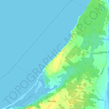
Name: Norway topographic map, elevation, terrain.

Location: Norway, Prince County, Prince Edward Island, Canada (46.99122 -64.06484 47.05098 -63.99783)

Average elevation: 4 m

Minimum elevation: -4 m

Maximum elevation: 22 m

Prince County trails, hiking, mountain biking, running and outdoor activities

Other topographic maps

Click on a map to view its topography, its elevation and its terrain.

Gear up for your next adventure:

🌡️Emergency Mylar Blankets - Compact thermal protection for unexpected nights outdoors
🧴Waterproofing Spray - Restore the DWR coating on jackets and tents
🚲MTB Frame Bag - Carry tools and maps directly on your bicycle frame
🥾Trail Hiking Socks - Comfortable socks to prevent blisters and fatigue
🕶️Polarized Sunglasses - Protect your eyes with durable polarized lenses

As an Amazon Associate, this site earns from qualifying purchases at no extra cost to you.