
Make a donation
Gear up for your next adventure:
As an Amazon Associate, this site earns from qualifying purchases at no extra cost to you.
Marktbergel topographic map
Click on the map to display elevation.
Make a donation
Gear up for your next adventure:
As an Amazon Associate, this site earns from qualifying purchases at no extra cost to you.
Marktbergel
Der Gemeindegebiet liegt östlich von Burgbernheim im nördlichsten Teil des Naturparks Frankenhöhe und der Frankenhöhe sowie darunter in der Tiefebene der Windsheimer Bucht, wo es im Norden bis an die Aischquelle und den Oberlauf der Aisch reicht, an dem das Terrain bis auf 317 m ü. NHN abfällt.
Make a donation
Gear up for your next adventure:
As an Amazon Associate, this site earns from qualifying purchases at no extra cost to you.
About this map
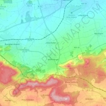
Name: Marktbergel topographic map, elevation, terrain.
Average elevation: 390 m
Minimum elevation: 315 m
Maximum elevation: 529 m
Make a donation
Gear up for your next adventure:
As an Amazon Associate, this site earns from qualifying purchases at no extra cost to you.
Other topographic maps
Click on a map to view its topography, its elevation and its terrain.
Ottenhofen
Deutschland > Bayern > Landkreis Neustadt an der Aisch-Bad Windsheim
Average elevation: 355 m