
Make a donation
Gear up for your next adventure:
As an Amazon Associate, this site earns from qualifying purchases at no extra cost to you.
Ottenhofen topographic map
Click on the map to display elevation.
Make a donation
Gear up for your next adventure:
As an Amazon Associate, this site earns from qualifying purchases at no extra cost to you.
About this map
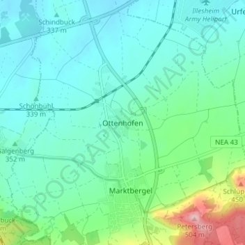
Name: Ottenhofen topographic map, elevation, terrain.
Average elevation: 355 m
Minimum elevation: 319 m
Maximum elevation: 490 m
Make a donation
Gear up for your next adventure:
As an Amazon Associate, this site earns from qualifying purchases at no extra cost to you.
Other topographic maps
Click on a map to view its topography, its elevation and its terrain.
Emskirchen
Deutschland > Bayern > Landkreis Neustadt an der Aisch-Bad Windsheim
Average elevation: 367 m
Uffenheim
Deutschland > Bayern > Landkreis Neustadt an der Aisch-Bad Windsheim
Die langjährigen Forschungen des Archäologischen Arbeitskreises am Gollachgaumuseum haben nicht nur für das Umland, sondern auch für die Frühgeschichte der Stadt wichtige neue Erkenntnisse geliefert, die 1999 in einem ersten Vorbericht publiziert wurden: Dazu gehören nicht nur Hinweise auf die Verteilung…
Average elevation: 370 m
Marktbergel
Deutschland > Bayern > Landkreis Neustadt an der Aisch-Bad Windsheim
Der Gemeindegebiet liegt östlich von Burgbernheim im nördlichsten Teil des Naturparks Frankenhöhe und der Frankenhöhe sowie darunter in der Tiefebene der Windsheimer Bucht, wo es im Norden bis an die Aischquelle und den Oberlauf der Aisch reicht, an dem das Terrain bis auf 317 m ü. NHN abfällt.
Average elevation: 390 m
Trautskirchen
Deutschland > Bayern > Landkreis Neustadt an der Aisch-Bad Windsheim
Die Gemeinde liegt im Naturpark Frankenhöhe. Durch das Gemeindegebiet fließt die Zenn.
Average elevation: 392 m
Make a donation
Gear up for your next adventure:
As an Amazon Associate, this site earns from qualifying purchases at no extra cost to you.