
Topanga topographic map
Click on the map to display elevation.
About this map
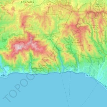
Name: Topanga topographic map, elevation, terrain.
Average elevation: 248 m
Minimum elevation: -1 m
Maximum elevation: 849 m
Other topographic maps
Click on a map to view its topography, its elevation and its terrain.
Santa Monica Mountains
United States > California > Los Angeles County > Malibu
On January 17, 2007, an unusually cold storm brought snow in the Santa Monica Mountains. The hills above Malibu picked up three inches (eight centimeters) of snow - the first measurable snow in fifty years. Snow was reported on Boney Peak in the winter of 2005; and in March 2006, snow also fell on the summit…
Average elevation: 288 m
Highland Camrose Park
United States > California > Los Angeles County > Los Angeles
Average elevation: 186 m
Deer Lake Highlands
United States > California > Los Angeles County > Unincorporated Chatsworth
Average elevation: 421 m
Veterans Administration
United States > California > Los Angeles County > Veterans Administration
Average elevation: 105 m
Verdugo City
United States > California > Los Angeles County > Glendale > Verdugo City
Average elevation: 472 m
Sierra Madre
United States > California > Los Angeles County > Sierra Madre > Sierra Madre
In 1908, the first Mt. Wilson Trail Race was run. This annual race was discontinued during WWII and reestablished in 1966. The 102nd anniversary of the first running of the Mount Wilson Trail Race and the 44th annual race was run in May 2010. Because of rain, mudslides, falling trees, soil erosion and…
Average elevation: 379 m