
Make a donation
Gear up for your next adventure:
As an Amazon Associate, this site earns from qualifying purchases at no extra cost to you.
Valico di Chiunzi topographic map
Click on the map to display elevation.
Make a donation
Gear up for your next adventure:
As an Amazon Associate, this site earns from qualifying purchases at no extra cost to you.
About this map
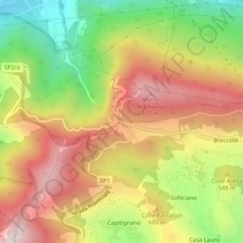
Name: Valico di Chiunzi topographic map, elevation, terrain.
Location: Valico di Chiunzi, Tramonti, Salerno, Campania, 84016, Italy (40.71870 14.61973 40.71880 14.61983)
Average elevation: 512 m
Minimum elevation: 78 m
Maximum elevation: 911 m
Make a donation
Gear up for your next adventure:
As an Amazon Associate, this site earns from qualifying purchases at no extra cost to you.
Other topographic maps
Click on a map to view its topography, its elevation and its terrain.
Acerno
The communal territory has an elevation varying between 400 and 1790 metres above sea level. Outside of the town itself it is entirely uninhabited by humans: there are no satellite hamlets or even scattered dwellings under permanent habitation. It is rich in flora, however, with forests of maple, oak,…
Average elevation: 954 m
Make a donation
Gear up for your next adventure:
As an Amazon Associate, this site earns from qualifying purchases at no extra cost to you.
Make a donation
Gear up for your next adventure:
As an Amazon Associate, this site earns from qualifying purchases at no extra cost to you.
Make a donation
Gear up for your next adventure:
As an Amazon Associate, this site earns from qualifying purchases at no extra cost to you.