Geolocate

Calvanico topographic map

Click on the map to display elevation.

About this map

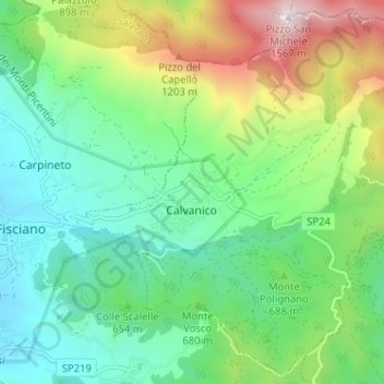
Name: Calvanico topographic map, elevation, terrain.

Location: Calvanico, Salerno, Campania, 84080, Italy (40.75438 14.81041 40.80063 14.87427)

Average elevation: 656 m

Minimum elevation: 264 m

Maximum elevation: 1,549 m

Other topographic maps

Click on a map to view its topography, its elevation and its terrain.

Montepertuso

Italy > Campania > Salerno > Arienzo

Average elevation: 455 m

Valico di Chiunzi

Italy > Campania > Salerno

Average elevation: 512 m

Persano

Italy > Campania > Salerno > Serre

Average elevation: 25 m

M.Licosa

Italy > Campania > Salerno

Average elevation: 114 m

Il Gallo Lungo

Italy > Campania > Salerno > Positano

Average elevation: 0 m

Sicilì

Italy > Campania > Salerno

Average elevation: 228 m

Gear up for your next adventure:

🔦LED Flashlight - Powerful and long-lasting flashlight for camping and emergencies
🧦Hiking Socks - Moisture-wicking and comfortable socks for long hikes
🛶Kayak Accessories - Essential gear for safe and fun kayaking adventures
👟Leg Gaiters - Keep debris, mud, and snow out of your boots
🐕Hiking Dog Pack - Let your canine companion carry their own water and food

As an Amazon Associate, this site earns from qualifying purchases at no extra cost to you.