
Ilorin South topographic map
Interactive map
Click on the map to display elevation.
About this map
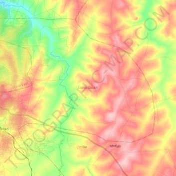
Name: Ilorin South topographic map, elevation, terrain.
Location: Ilorin South, Kwara State, Nigeria (8.37160 4.58230 8.50829 4.75583)
Average elevation: 355 m
Minimum elevation: 266 m
Maximum elevation: 430 m
Other topographic maps
Click on a map to view its topography, its elevation and its terrain.
Omu Aran
Nigeria > Kwara State > Irepodun
Omu Aran, Irepodun, Kwara State, 251101, Nigeria
Average elevation: 539 m
Araromi-Opin
Nigeria > Kwara State > Ekiti
Araromi-Opin, Ekiti, Kwara State, Nigeria
Average elevation: 505 m