
Stara planina topographic map
Interactive map
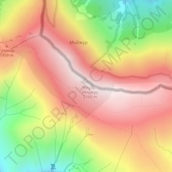
Click on the map to display elevation.
About this map
Name: Stara planina topographic map, elevation, terrain.
Average elevation: 1,806 m
Minimum elevation: 1,322 m
Maximum elevation: 2,161 m
The vertebrate fauna of Central Balkan National Park consists of 309 species. The number of mammal species is 60, including animals of high conservation value, such as brown bear, gray wolf, wildcat, marbled polecat, European pine marten, Eurasian otter, the only population of chamois within the mountain range, European ground squirrel, lesser mole-rat, European snow vole, etc. The avifauna includes 220 species, of which 123 are nesting. The park is important for the protection of the eastern imperial eagle, saker falcon, Eurasian eagle-owl, Eurasian pygmy owl, Ural owl, boreal owl, white-backed woodpecker, semicollared flycatcher and corn crake. The park's herpetofauna includes 15 reptile and nine amphibian species. It hosts population of national importance of common European adder, viviparous lizard and common frog. Due to the park's high altitude, the ichthyofauna consists of six fish species, with brown trout being the dominant one.
Other topographic maps
Click on a map to view its topography, its elevation and its terrain.
Zaskovci
Serbia > Central Serbia > Pirot Administrative District > City of Pirot
Zaskovci, City of Pirot, Pirot Administrative District, Central Serbia, Serbia
Average elevation: 970 m