
Make a donation
Gear up for your next adventure:
As an Amazon Associate, this site earns from qualifying purchases at no extra cost to you.
Leutenbach topographic map
Click on the map to display elevation.
Make a donation
Gear up for your next adventure:
As an Amazon Associate, this site earns from qualifying purchases at no extra cost to you.
Leutenbach
Leutenbach liegt in 254 bis 420 Metern Höhe am Rande des Schwäbischen Waldes und der Backnanger Bucht. Durch die Gemeinde fließen der Buchenbach, der Rotbach und der Höllachbach.
Make a donation
Gear up for your next adventure:
As an Amazon Associate, this site earns from qualifying purchases at no extra cost to you.
About this map
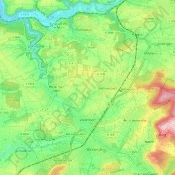
Name: Leutenbach topographic map, elevation, terrain.
Average elevation: 301 m
Minimum elevation: 209 m
Maximum elevation: 453 m
Make a donation
Gear up for your next adventure:
As an Amazon Associate, this site earns from qualifying purchases at no extra cost to you.
Other topographic maps
Click on a map to view its topography, its elevation and its terrain.
Kirchenkirnberg
Deutschland > Baden-Württemberg > Rems-Murr-Kreis > Murrhardt
Average elevation: 480 m
Stöckenhof
Deutschland > Baden-Württemberg > Rems-Murr-Kreis > Berglen > Öschelbronn
Average elevation: 362 m
Make a donation
Gear up for your next adventure:
As an Amazon Associate, this site earns from qualifying purchases at no extra cost to you.
Make a donation
Gear up for your next adventure:
As an Amazon Associate, this site earns from qualifying purchases at no extra cost to you.
Hertmannsweiler
Deutschland > Baden-Württemberg > Rems-Murr-Kreis > Winnenden > Hertmannsweiler
Average elevation: 329 m
Vordersteinenberg
Deutschland > Baden-Württemberg > Rems-Murr-Kreis > Alfdorf > Vordersteinenberg
Average elevation: 489 m
Zwingelhausen
Deutschland > Baden-Württemberg > Rems-Murr-Kreis > Kirchberg an der Murr
Average elevation: 302 m
Make a donation
Gear up for your next adventure:
As an Amazon Associate, this site earns from qualifying purchases at no extra cost to you.