
Make a donation
Gear up for your next adventure:
As an Amazon Associate, this site earns from qualifying purchases at no extra cost to you.
Beilsbach topographic map
Click on the map to display elevation.
Make a donation
Gear up for your next adventure:
As an Amazon Associate, this site earns from qualifying purchases at no extra cost to you.
About this map
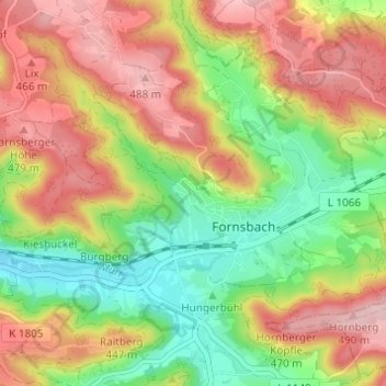
Name: Beilsbach topographic map, elevation, terrain.
Average elevation: 398 m
Minimum elevation: 301 m
Maximum elevation: 498 m
Make a donation
Gear up for your next adventure:
As an Amazon Associate, this site earns from qualifying purchases at no extra cost to you.
Other topographic maps
Click on a map to view its topography, its elevation and its terrain.
Murrhardt
Deutschland > Baden-Württemberg > Rems-Murr-Kreis > Murrhardt
Die Anfänge der Stadt Murrhardt liegen in der Römerzeit, als 161 n. Chr. die römische Reichsgrenze aus dem Tal des Neckars nach Osten auf die noch unwirtlichen Höhen des Schwäbischen Waldes verlegt wurde. Die römischen Kastellgründungen waren Keimzellen zahlreicher neuer Siedlungen wie Lorch, Welzheim,…
Average elevation: 428 m