Geolocate

Van Alstyne topographic map

Click on the map to display elevation.

About this map

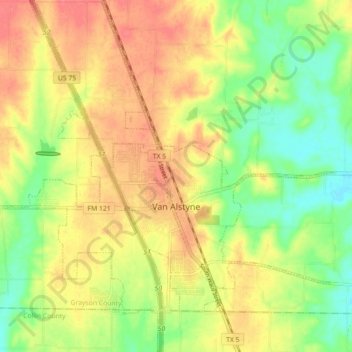
Name: Van Alstyne topographic map, elevation, terrain.

Location: Van Alstyne, Grayson County, Texas, 75495, United States (33.39133 -96.62037 33.46542 -96.53617)

Average elevation: 227 m

Minimum elevation: 195 m

Maximum elevation: 254 m

Other topographic maps

Click on a map to view its topography, its elevation and its terrain.

Whitesboro

United States > Texas > Grayson County

Average elevation: 236 m

Gordonville

United States > Texas > Grayson County

Average elevation: 211 m

Tribune

United States > Texas > Grayson County > Sherman

Average elevation: 208 m

Mills

United States > Texas > Grayson County > Denison

Average elevation: 208 m

Gear up for your next adventure:

💧Hydration Pack - Hands-free hydration system for long hikes
🧼Biodegradable Camp Soap - Environmentally friendly cleaning for gear and body
Family Camping Tent - Spacious tent suitable for family camping trips
🕶️Polarized Sunglasses - Protect your eyes with durable polarized lenses
🥾Hiking Gaiters - Protect legs and shoes from mud, snow, and debris

As an Amazon Associate, this site earns from qualifying purchases at no extra cost to you.