Geolocate

Warsop Vale topographic map

Click on the map to display elevation.

About this map

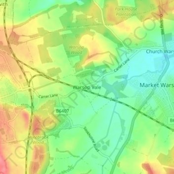
Name: Warsop Vale topographic map, elevation, terrain.

Location: Warsop Vale, Mansfield, Nottinghamshire, England, NG20 8XE, United Kingdom (53.18478 -1.20072 53.22478 -1.16072)

Average elevation: 81 m

Minimum elevation: 51 m

Maximum elevation: 120 m

Other topographic maps

Click on a map to view its topography, its elevation and its terrain.

Warsop

United Kingdom > England > Nottinghamshire > Mansfield

Average elevation: 79 m

Gear up for your next adventure:

🥾Hiking Gaiters - Protect legs and shoes from mud, snow, and debris
Camping Coffee Maker - Brew fresh coffee anywhere on the topographic map
🥾Mountain Hiking Shoes - Shoes with superior grip for mountainous terrain
🥾Light Trekking Boots - Supportive boots for multi-day treks
🧢Sun Protection Cap - Breathable cap to protect from sun exposure

As an Amazon Associate, this site earns from qualifying purchases at no extra cost to you.