
Make a donation
Gear up for your next adventure:
As an Amazon Associate, this site earns from qualifying purchases at no extra cost to you.
Baralla topographic map
Click on the map to display elevation.
Make a donation
Gear up for your next adventure:
As an Amazon Associate, this site earns from qualifying purchases at no extra cost to you.
Baralla
Der Río Neira, ein Nebenfluss des Río Miño, durchströmt das Gebiet der Gemeinde von Nordost kommend in südöstlicher Richtung. Das Relief der Gemeinde wird durch das Tal des Flusses geprägt, das sich zwischen den westlichsten Erhebungen der Sierra de Ancares (Serra do Rañadoiro im Norden, Serra do Picato im Westen, Serra de Piñeira im Südosten) befindet. Die Höhe schwankt zwischen 943 m (Serra do Rañadoiro) und 420 m am Ufer des Flusses Neira.
Make a donation
Gear up for your next adventure:
As an Amazon Associate, this site earns from qualifying purchases at no extra cost to you.
About this map
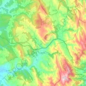
Name: Baralla topographic map, elevation, terrain.
Location: Baralla, Os Ancares, Lugo, Galicien, Spanien (42.83296 -7.35078 42.99022 -7.15711)
Average elevation: 684 m
Minimum elevation: 405 m
Maximum elevation: 1,170 m
Make a donation
Gear up for your next adventure:
As an Amazon Associate, this site earns from qualifying purchases at no extra cost to you.
Other topographic maps
Click on a map to view its topography, its elevation and its terrain.