
Make a donation
Gear up for your next adventure:
As an Amazon Associate, this site earns from qualifying purchases at no extra cost to you.
Padornelo topographic map
Click on the map to display elevation.
Make a donation
Gear up for your next adventure:
As an Amazon Associate, this site earns from qualifying purchases at no extra cost to you.
About this map
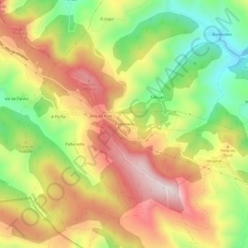
Name: Padornelo topographic map, elevation, terrain.
Average elevation: 1,212 m
Minimum elevation: 951 m
Maximum elevation: 1,463 m
Make a donation
Gear up for your next adventure:
As an Amazon Associate, this site earns from qualifying purchases at no extra cost to you.
Other topographic maps
Click on a map to view its topography, its elevation and its terrain.
O Cebreiro
Spanien > Galicien > Os Ancares > Pedrafita do Cebreiro
O Cebreiro liegt auf etwa 1300 Meter Höhe ü. d. M. unweit des Cebreiro-Passes, einer bereits in der Antike genutzten Verbindung zwischen den Hochebenen (mesetas) von Kastilien-León und Galicien.
Average elevation: 1,105 m