Geolocate

Chungthang topographic map

Click on the map to display elevation.

About this map

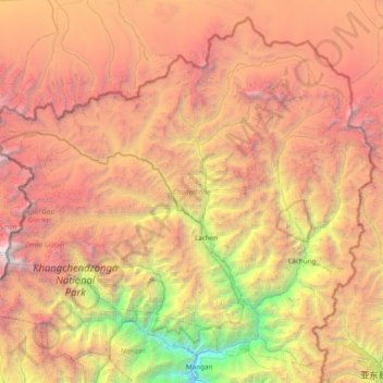
Name: Chungthang topographic map, elevation, terrain.

Location: Chungthang, Mangan District, Sikkim, 737120, India (27.50222 88.11800 28.12264 88.88812)

Average elevation: 4,598 m

Minimum elevation: 852 m

Maximum elevation: 8,447 m

Other topographic maps

Click on a map to view its topography, its elevation and its terrain.

Mangan

India > Sikkim > Mangan

Average elevation: 1,388 m

Gear up for your next adventure:

💡Solar Camping Lamp - Eco-friendly lighting for campsites
💧Filtered Water Bottle - Safe drinking water on the go
🛌Down Sleeping Bag - Superior warmth-to-weight ratio for cold nights
🥾Hiking Boots - Sturdy boots providing ankle support and traction on rugged trails
🧼Biodegradable Camp Soap - Environmentally friendly cleaning for gear and body

As an Amazon Associate, this site earns from qualifying purchases at no extra cost to you.