Geolocate

Mangan topographic map

Click on the map to display elevation.

About this map

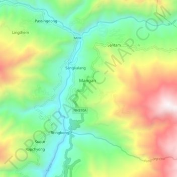
Name: Mangan topographic map, elevation, terrain.

Location: Mangan, North Sikkim District, Sikkim, 737116, India (27.46115 88.49553 27.54115 88.57553)

Average elevation: 1,388 m

Minimum elevation: 639 m

Maximum elevation: 2,717 m

Gear up for your next adventure:

🥾Trail Hiking Boots - Supportive boots for rough trails
🦯Trekking Poles - Reduced impact on joints for steep topographic climbs
Family Camping Tent - Spacious tent suitable for family camping trips
🧭GPS Handheld Device - Reliable GPS navigation for outdoor adventures
💧Filtered Water Bottle - Safe drinking water on the go

As an Amazon Associate, this site earns from qualifying purchases at no extra cost to you.