Geolocate

Beykoz topographic map

Click on the map to display elevation.

About this map

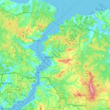
Name: Beykoz topographic map, elevation, terrain.

Location: Beykoz, Istanbul, Marmara Region, Turkey (41.04229 29.06425 41.23533 29.36540)

Average elevation: 93 m

Minimum elevation: -1 m

Maximum elevation: 429 m

Other topographic maps

Click on a map to view its topography, its elevation and its terrain.

Bebek Parkı

Turkey > Istanbul > Beşiktaş

Average elevation: 63 m

Istanbul

Turkey > Istanbul > Fatih

Average elevation: 57 m

Binkılıç

Turkey > Istanbul > Çatalca

Average elevation: 206 m

Heybeliada

Turkey > Istanbul > Prince Islands

Average elevation: 11 m

Istanbul

Turkey > Istanbul > Fatih

Average elevation: 57 m

Tenzile Erdoğan Parkı 1

Turkey > Istanbul > Pendik

Average elevation: 106 m

Binkılıç

Turkey > Istanbul > Çatalca

Average elevation: 206 m

Almaata Çocuk Parkı

Turkey > Istanbul > Avcılar

Average elevation: 23 m

Binkılıç

Turkey > Istanbul > Çatalca

Average elevation: 206 m

Moda Parkı

Turkey > Istanbul > Kadıköy

Average elevation: 4 m

Gear up for your next adventure:

🥾Hiking Boots - Sturdy boots providing ankle support and traction on rugged trails
🧣Evaporative Cooling Towel - Beat the heat during intense summer climbs
🧥Waterproof Hiking Jacket - Protect yourself from rain and wind while hiking
🌡️Emergency Mylar Blankets - Compact thermal protection for unexpected nights outdoors
🛶Kayak Dry Bag - Waterproof storage for kayaking adventures

As an Amazon Associate, this site earns from qualifying purchases at no extra cost to you.