Geolocate

Alicudi topographic map

Click on the map to display elevation.

About this map

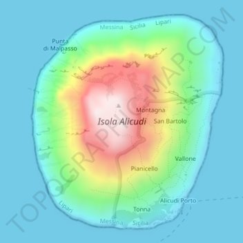
Name: Alicudi topographic map, elevation, terrain.

Location: Alicudi, Lipari, Messina, Sicily, Italy (38.53072 14.33904 38.55452 14.36630)

Average elevation: 154 m

Minimum elevation: 0 m

Maximum elevation: 661 m

Other topographic maps

Click on a map to view its topography, its elevation and its terrain.

Stromboli

Italy > Sicily > Messina > Lipari

Average elevation: 372 m

Stromboli Volcano trail

Italy > Sicily > Messina > Lipari

Average elevation: 376 m

Vulcano

Italy > Sicily > Messina > Lipari

Average elevation: 124 m

Cavoni

Italy > Sicily > Messina > Lipari

Average elevation: 216 m

Vulcano Porto

Italy > Sicily > Messina > Lipari

Average elevation: 50 m

Vulcanello

Italy > Sicily > Messina > Lipari > Vulcano Porto

Average elevation: 25 m

Gear up for your next adventure:

🎒Fully Waterproof Backpack - Total protection for photography gear and electronics
🏕️Camping Hammock - Integrated protection for sleeping between trees
🥾Hiking Leggings - Comfortable leggings for outdoor activities
🛶Kayak Dry Bag - Waterproof storage for kayaking adventures
🧭GPS Handheld Device - Reliable GPS navigation for outdoor adventures

As an Amazon Associate, this site earns from qualifying purchases at no extra cost to you.