Geolocate

Vulcano Porto topographic map

Click on the map to display elevation.

About this map

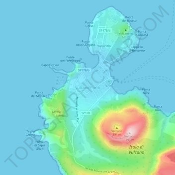
Name: Vulcano Porto topographic map, elevation, terrain.

Location: Vulcano Porto, Lipari, Messina, Sicily, 98050, Italy (38.39367 14.93314 38.43367 14.97314)

Average elevation: 50 m

Minimum elevation: 0 m

Maximum elevation: 386 m

Other topographic maps

Click on a map to view its topography, its elevation and its terrain.

Isola di Vulcano

Italy > Sicily > Messina > Lipari

Average elevation: 76 m

Isola di Stromboli

Italy > Sicily > Messina > Lipari

Average elevation: 160 m

Alicudi

Italy > Sicily > Messina > Lipari

Average elevation: 154 m

Alicudi

Italy > Sicily > Messina > Lipari

Average elevation: 154 m

Gear up for your next adventure:

🛏️Camping Sleeping Mat - Comfortable mats for sleeping outdoors
🎒Hiking Backpack - Lightweight and ergonomic backpacks for day hikes or multi-day treks
🥾Mountain Hiking Shoes - Shoes with superior grip for mountainous terrain
🥾Mountain Hiking Boots - High-traction boots for rocky terrain
🛶Kayak Accessories - Essential gear for safe and fun kayaking adventures

As an Amazon Associate, this site earns from qualifying purchases at no extra cost to you.