Geolocate

St. Mabyn topographic map

Click on the map to display elevation.

About this map

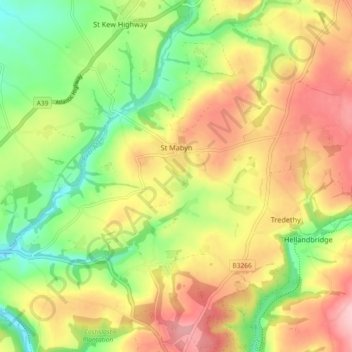
Name: St. Mabyn topographic map, elevation, terrain.

Location: St. Mabyn, Cornwall, England, United Kingdom (50.49636 -4.78861 50.54672 -4.69744)

Average elevation: 82 m

Minimum elevation: 2 m

Maximum elevation: 166 m

Other topographic maps

Click on a map to view its topography, its elevation and its terrain.

Trembraze

United Kingdom > England > Cornwall > Liskeard

Average elevation: 128 m

Freathy

United Kingdom > England > Cornwall

Average elevation: 37 m

Riviere Towans

United Kingdom > England > Cornwall > Hayle > Phillack

Average elevation: 19 m

Pinnacle Gully

United Kingdom > England > Cornwall > Porthgwarra

Average elevation: 19 m

Gear up for your next adventure:

🔦LED Headtorch - Bright and durable light for night activities
🧶550 Survival Paracord - Versatile utility cord for emergency repairs and rigging
Camping Essentials - All-in-one gear for a comfortable camping trip
👟Trail Running Shoes - Agile footwear for fast-paced topographic exploration
🥾Mountain Hiking Boots - High-traction boots for rocky terrain

As an Amazon Associate, this site earns from qualifying purchases at no extra cost to you.