Geolocate

Mata topographic map

Click on the map to display elevation.

About this map

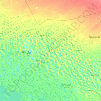
Name: Mata topographic map, elevation, terrain.

Location: Mata, Chad (13.15539 14.55126 13.79539 15.19126)

Average elevation: 291 m

Minimum elevation: 276 m

Maximum elevation: 320 m

Other topographic maps

Click on a map to view its topography, its elevation and its terrain.

Bahr El Gazal

Chad > Bahr el Gazel

Average elevation: 289 m

Doba

Chad > Logone Oriental

Average elevation: 388 m

Borkou

Chad

Average elevation: 363 m

Mayo-Kebbi Ouest

Chad

Average elevation: 366 m

Ennedi-Ouest

Chad

Average elevation: 610 m

Salamat

Chad > Salamat

Average elevation: 450 m

N'Djamena

Chad

Average elevation: 294 m

Gear up for your next adventure:

🥾Mountain Hiking Boots - High-traction boots for rocky terrain
🔭Compact Monocular - One-handed bird watching and trail spotting
🧥Ultralight Puffy Jacket - Maximum warmth that packs down to the size of an orange
Bushcraft Tarp - Versatile emergency shelter or gear protection
🧊Insulated Water Bottle - Keeps drinks cold in summer and prevents freezing in winter

As an Amazon Associate, this site earns from qualifying purchases at no extra cost to you.