Geolocate

Maasdijk topographic map

Click on the map to display elevation.

About this map

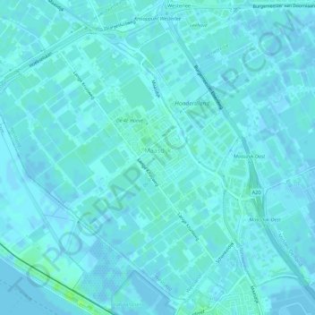
Name: Maasdijk topographic map, elevation, terrain.

Location: Maasdijk, Westland, South Holland, Netherlands (51.94138 4.18672 51.97199 4.24127)

Average elevation: 2 m

Minimum elevation: -4 m

Maximum elevation: 8 m

Other topographic maps

Click on a map to view its topography, its elevation and its terrain.

Botlek

Netherlands > South Holland

Average elevation: 3 m

Langeraar

Netherlands > South Holland

Average elevation: -3 m

Meije

Netherlands > South Holland > Nieuwkoop

Average elevation: -2 m

Weerestein

Netherlands > South Holland > Hillegom

Average elevation: 0 m

Broekhuizen

Netherlands > South Holland > Gouda

Average elevation: -1 m

Ankerpark

Netherlands > South Holland > Leiden

Average elevation: 3 m

Middelsluis

Netherlands > South Holland > Numansdorp

Average elevation: 0 m

Weerestein

Netherlands > South Holland > Hillegom

Average elevation: 0 m

Meijendel

Netherlands > South Holland > Wassenaar

Average elevation: 6 m

Coepelduynen

Netherlands > South Holland > Katwijk

Average elevation: 4 m

Het Park

Netherlands > South Holland > Rotterdam

Average elevation: 4 m

Waalhaven

Netherlands > South Holland > Rotterdam

Average elevation: 3 m

Gear up for your next adventure:

💧Collapsible Water Bottle - Space-saving water bottle for outdoor activities
🔦LED Headtorch - Bright and durable light for night activities
Camping Coffee Maker - Brew fresh coffee anywhere on the topographic map
🦶Anti-Blister Balm - Prevents friction and hotspots during long ascents
🧴Insect Repellent - Protect yourself from bugs during outdoor adventures

As an Amazon Associate, this site earns from qualifying purchases at no extra cost to you.