
Make a donation
Gear up for your next adventure:
As an Amazon Associate, this site earns from qualifying purchases at no extra cost to you.
Insel topographic map
Click on the map to display elevation.
Make a donation
Gear up for your next adventure:
As an Amazon Associate, this site earns from qualifying purchases at no extra cost to you.
Insel
Insel, ein Dorf mit Kirche, liegt etwa 10 km von Stendal entfernt in der Altmark. Das Gelände fällt vom Tangermünder-Buchholzer Höhenzug in Richtung Norden zur Uchteniederung ab. Nördlich von Insel liegt die ehemalige Kiesgrube Hillberg.
Make a donation
Gear up for your next adventure:
As an Amazon Associate, this site earns from qualifying purchases at no extra cost to you.
About this map
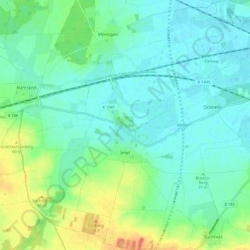
Name: Insel topographic map, elevation, terrain.
Location: Insel, Stendal, Sachsen-Anhalt, Deutschland (52.53572 11.70296 52.60209 11.81227)
Average elevation: 44 m
Minimum elevation: 32 m
Maximum elevation: 75 m
Make a donation
Gear up for your next adventure:
As an Amazon Associate, this site earns from qualifying purchases at no extra cost to you.
Other topographic maps
Click on a map to view its topography, its elevation and its terrain.
Schnöggersburg (Wüstung)
Deutschland > Sachsen-Anhalt > Stendal > Stendal > Staats
Average elevation: 100 m