Geolocate

Outeiro topographic map

Click on the map to display elevation.

About this map

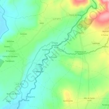
Name: Outeiro topographic map, elevation, terrain.

Location: Outeiro, Veiga, A Pobra do Brollón, Tierra de Lemos, Lugo, Galicia, 27333, España (42.57455 -7.43061 42.61455 -7.39061)

Average elevation: 416 m

Minimum elevation: 348 m

Maximum elevation: 553 m

Other topographic maps

Click on a map to view its topography, its elevation and its terrain.

Saa

España > Galicia > Tierra de Lemos > A Pobra do Brollón

Average elevation: 736 m

Cereixa

España > Galicia > Tierra de Lemos > A Pobra do Brollón

Average elevation: 397 m

Canedo

España > Galicia > Tierra de Lemos > A Pobra do Brollón

Se encuentra en la zona septentrional del municipio de Puebla del Brollón. La altitud aumenta de oeste a este, donde se encuentran los dos puntos más altos: Alto do Pedregal (664,8 m) y Pico do Santo (644,7 m).

Average elevation: 493 m

Eixón

España > Galicia > Tierra de Lemos > A Pobra do Brollón

Average elevation: 382 m

Óutara

España > Galicia > Tierra de Lemos > A Pobra do Brollón

Average elevation: 598 m

Gear up for your next adventure:

🧥Insulated Jacket - Keep warm in cold outdoor conditions
🛰️Satellite Messenger - Emergency communication for areas with no cell service
Camping Essentials - All-in-one gear for a comfortable camping trip
🪑Insulated Seat Pad - Protect your seat from cold rocks and wet logs
🥾Lightweight Hiking Shoes - Comfortable shoes for day hikes

As an Amazon Associate, this site earns from qualifying purchases at no extra cost to you.