Geolocate

Saa topographic map

Click on the map to display elevation.

About this map

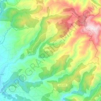
Name: Saa topographic map, elevation, terrain.

Location: Saa, A Pobra do Brollón, Tierra de Lemos, Lugo, Galicia, 27336, España (42.56553 -7.39352 42.61771 -7.28129)

Average elevation: 736 m

Minimum elevation: 396 m

Maximum elevation: 1,298 m

Other topographic maps

Click on a map to view its topography, its elevation and its terrain.

Covos

España > Galicia > Tierra de Lemos > A Pobra do Brollón

Average elevation: 553 m

Outeiro

España > Galicia > Tierra de Lemos > A Pobra do Brollón

Average elevation: 416 m

Gear up for your next adventure:

🥽Outdoor Goggles - Protective eyewear for outdoor activities
Camping Tent - Weather-resistant tents suitable for 2 to 6 people
🗺️Topographic Maps - Detailed maps to explore trails, mountains, and wilderness areas
🧤Rechargeable Heated Gloves - Extreme warmth for Canadian winter expeditions
💧Hydration Pack - Hands-free hydration system for long hikes

As an Amazon Associate, this site earns from qualifying purchases at no extra cost to you.