Geolocate

Parvati Parbat topographic map

Click on the map to display elevation.

About this map

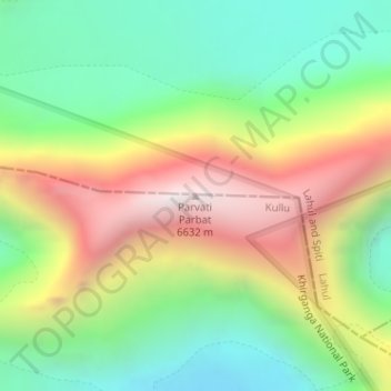
Name: Parvati Parbat topographic map, elevation, terrain.

Location: Parvati Parbat, Kullu, Himachal Pradesh, India (32.09049 77.73462 32.09059 77.73472)

Average elevation: 5,814 m

Minimum elevation: 5,258 m

Maximum elevation: 6,614 m

Other topographic maps

Click on a map to view its topography, its elevation and its terrain.

Rohru

India > Himachal Pradesh

Average elevation: 2,278 m

Chitkul

India > Himachal Pradesh > Sangla

Average elevation: 3,695 m

Ani

India > Himachal Pradesh

Average elevation: 2,071 m

Kasauli

India > Himachal Pradesh

Average elevation: 1,065 m

jakhu park

India > Himachal Pradesh > Shimla > Sniwoan

Average elevation: 2,101 m

Indora

India > Himachal Pradesh

Average elevation: 427 m

Una

India > Himachal Pradesh

Average elevation: 448 m

Bara Shigri Glacier

India > Himachal Pradesh > Lahul

Average elevation: 5,369 m

Krishangarh

India > Himachal Pradesh

Average elevation: 948 m

Arki

India > Himachal Pradesh

Average elevation: 1,173 m

Spiti

India > Himachal Pradesh

Average elevation: 4,906 m

Chamba

India > Himachal Pradesh

Average elevation: 2,360 m

Rampur

India > Himachal Pradesh > Rampur

Average elevation: 2,945 m

Lahul

India > Himachal Pradesh > Lahul

Average elevation: 4,551 m

Poo

India > Himachal Pradesh > Kinnaur

Average elevation: 4,373 m

Gear up for your next adventure:

Backpacking Tent - Lightweight tent for long-distance hiking trips
🥾Hiking Leggings - Comfortable leggings for outdoor activities
💡Portable Camping Lamp - Rechargeable lamp for campsite lighting
🛌Down Sleeping Bag - Superior warmth-to-weight ratio for cold nights
💡Solar Camping Lamp - Eco-friendly lighting for campsites

As an Amazon Associate, this site earns from qualifying purchases at no extra cost to you.