
Make a donation
Gear up for your next adventure:
As an Amazon Associate, this site earns from qualifying purchases at no extra cost to you.
Carmel Valley topographic map
Click on the map to display elevation.
Make a donation
Gear up for your next adventure:
As an Amazon Associate, this site earns from qualifying purchases at no extra cost to you.
About this map
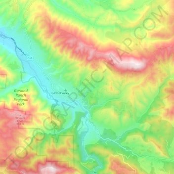
Name: Carmel Valley topographic map, elevation, terrain.
Location: Carmel Valley, Monterey County, California, United States (36.43522 -121.77103 36.53058 -121.65765)
Average elevation: 335 m
Minimum elevation: 42 m
Maximum elevation: 718 m
Make a donation
Gear up for your next adventure:
As an Amazon Associate, this site earns from qualifying purchases at no extra cost to you.
Other topographic maps
Click on a map to view its topography, its elevation and its terrain.
Make a donation
Gear up for your next adventure:
As an Amazon Associate, this site earns from qualifying purchases at no extra cost to you.
King City
United States > California > Monterey County
King City (variants: Kings City, City of King) is a city in Monterey County, California, United States. It is located on the Salinas River 51 miles (82 km) southeast of Salinas, at an elevation of 335 feet (102 m). It lies along U.S. Route 101 in the Salinas Valley of California's Central Coast. King City is a…
Average elevation: 93 m
Prunedale
United States > California > Monterey County > Prunedale
Prunedale is a census-designated place in Monterey County, California. Prunedale is located 8 miles (13 km) north of Salinas, at an elevation of 92 feet (28 m). The population was 17,560 residents at the time of the 2010 census, up from 16,432 at the 2000 census. Plum trees were grown in Prunedale in the early…
Average elevation: 69 m
Make a donation
Gear up for your next adventure:
As an Amazon Associate, this site earns from qualifying purchases at no extra cost to you.
Pajaro
United States > California > Monterey County > Pajaro
Pajaro (Spanish Pájaro 'bird') is an unincorporated community and census-designated place (CDP) in Monterey County, California. It is located on the south bank of the Pajaro River 5 miles (8 km) northeast of its mouth, at an elevation of 26 feet (7.9 m). The population was 2,882 at the 2020 census, down from…
Average elevation: 11 m
Bradley
United States > California > Monterey County
Bradley is an unincorporated community and census-designated place (CDP) in Monterey County, California, on the Salinas River 14 miles (23 km) south-southeast of San Ardo and 20 miles (32 km) north of Paso Robles. Bradley sits at an elevation of 548 feet (167 m). The population was 69 at the 2020 census, down…
Average elevation: 190 m
Make a donation
Gear up for your next adventure:
As an Amazon Associate, this site earns from qualifying purchases at no extra cost to you.
Del Rey Oaks
United States > California > Monterey County
Del Rey Oaks (Del Rey, Spanish for "Of the King") is a city in Monterey County, California, United States. It is located just southeast of Seaside, at an elevation of 82 feet (25 m). The population was 1,592 at the 2020 census. Del Rey Oaks is a member of the Association of Monterey Bay Area Governments, a…
Average elevation: 57 m
Make a donation
Gear up for your next adventure:
As an Amazon Associate, this site earns from qualifying purchases at no extra cost to you.
Make a donation
Gear up for your next adventure:
As an Amazon Associate, this site earns from qualifying purchases at no extra cost to you.
King City
United States > California > Monterey County
King City (variant: Kings City) is a city in Monterey County, California, United States. It is located on the Salinas River 51 miles (82 km) southeast of Salinas, at an elevation of 335 feet (102 m). It lies along U.S. Route 101 in the Salinas Valley of California's Central Coast. King City is a member of the…
Average elevation: 101 m
Las Lomas
United States > California > Monterey County
Las Lomas (Spanish for "The Hills") is an unincorporated community and census-designated place (CDP) in Monterey County, California, United States. Las Lomas is located 7 miles (11 km) north-northwest of Prunedale. The elevation is 43 feet (13 m). The population was 3,046 at the 2020 census.
Average elevation: 35 m
Greenfield
United States > California > Monterey County
Greenfield (formerly Clarke Colony) is a city in Monterey County, California, United States. It lies in the Salinas Valley, 33 miles (53 km) southeast of Salinas, at an elevation of 289 feet (88 m). As of the 2020 census, the population was 18,937, up from 16,330 in the 2010 census. Its most well-known public…
Average elevation: 86 m