
Legbourne topographic map
Click on the map to display elevation.
About this map
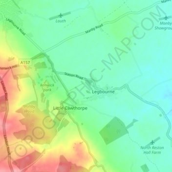
Name: Legbourne topographic map, elevation, terrain.
Location: Legbourne, East Lindsey, Lincolnshire, England, United Kingdom (53.31972 0.00881 53.36021 0.08227)
Average elevation: 37 m
Minimum elevation: 7 m
Maximum elevation: 100 m
Other topographic maps
Click on a map to view its topography, its elevation and its terrain.
The Lymn
United Kingdom > England > Lincolnshire > East Lindsey > Thorpe St. Peter
Average elevation: 2 m
Kirkby Fenside
United Kingdom > England > Lincolnshire > East Lindsey > East Kirkby
Average elevation: 12 m
Acre Bridge
United Kingdom > England > Lincolnshire > East Lindsey > Conisholme
Average elevation: 2 m
Wainfleet Haven
United Kingdom > England > Lincolnshire > East Lindsey > Wainfleet Clough
Average elevation: 3 m
Halton Fenside
United Kingdom > England > Lincolnshire > East Lindsey > Little Steeping
Average elevation: 8 m
Louth Navigation
United Kingdom > England > Lincolnshire > East Lindsey > Alvingham
Average elevation: 8 m
Belleau Bridge
United Kingdom > England > Lincolnshire > East Lindsey > Aby > Belleau
Average elevation: 30 m
Ashby by Partney
United Kingdom > England > Lincolnshire > East Lindsey > Halton Holegate
Average elevation: 20 m
Fishtoft Drove
United Kingdom > England > Lincolnshire > East Lindsey > Frithville
Average elevation: 4 m
Bag Enderby
United Kingdom > England > Lincolnshire > East Lindsey > Bag Enderby
Average elevation: 56 m
Sutton le Marsh
United Kingdom > England > Lincolnshire > East Lindsey > Sutton-on-Sea > Sutton le Marsh
Average elevation: 1 m
Low Hameringham
United Kingdom > England > Lincolnshire > East Lindsey > Low Hameringham
Average elevation: 72 m
Boothby
United Kingdom > England > Lincolnshire > East Lindsey > Welton le Marsh
Average elevation: 12 m
Poolham
United Kingdom > England > Lincolnshire > East Lindsey > Horsington > Poolham
Average elevation: 18 m
Bowser's Corner
United Kingdom > England > Lincolnshire > East Lindsey > New Leake
Average elevation: 1 m