Geolocate

Cawston topographic map

Click on the map to display elevation.

About this map

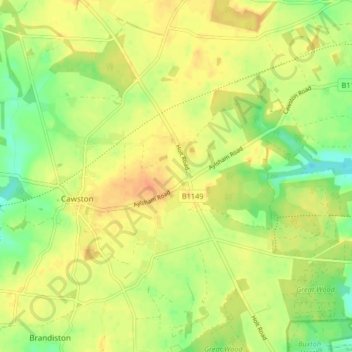
Name: Cawston topographic map, elevation, terrain.

Location: Cawston, Broadland, Norfolk, East of England, England, United Kingdom (52.75058 1.14212 52.79677 1.22464)

Average elevation: 42 m

Minimum elevation: 22 m

Maximum elevation: 56 m

Other topographic maps

Click on a map to view its topography, its elevation and its terrain.

Southgate

United Kingdom > England > Norfolk > Broadland > Cawston

Average elevation: 42 m

Limpenhoe

United Kingdom > England > Norfolk > Broadland

Average elevation: 7 m

Gear up for your next adventure:

🕶️Polarized Sunglasses - Reduces glare from snow and water at high elevations
💡LED Headlamp - Hands-free illumination for night hiking and camping
🪜Heavy Duty Carabiners - Multi-use clips for securing gear to your backpack
🧼Travel Hand Sanitizer - Keep hands clean when water is scarce
💧Hydration Pack - Hands-free hydration system for long hikes

As an Amazon Associate, this site earns from qualifying purchases at no extra cost to you.