Geolocate

Nazas topographic map

Click on the map to display elevation.

About this map

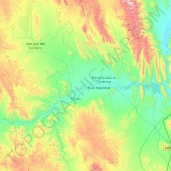
Name: Nazas topographic map, elevation, terrain.

Location: Nazas, Durango, Mexico (24.95566 -104.38345 25.58629 -103.77797)

Average elevation: 1,589 m

Minimum elevation: 1,162 m

Maximum elevation: 2,629 m

Other topographic maps

Click on a map to view its topography, its elevation and its terrain.

Coscomate

Mexico > Durango > Pueblo Nuevo

Average elevation: 2,528 m

Ciénega de la Vaca

Mexico > Durango > Guanaceví

Average elevation: 2,994 m

La Rosilla

Mexico > Durango > Guanaceví

Average elevation: 2,074 m

Tlahualilo

Mexico > Durango

Average elevation: 1,136 m

General Carlos Real

Mexico > Durango > Municipio de Durango

Average elevation: 1,882 m

El Nayar

Mexico > Durango > Municipio de Durango

Average elevation: 1,927 m

Villa Unión

Mexico > Durango > Poanas

Average elevation: 1,915 m

El Pelón

Mexico > Durango > Canatlán

Average elevation: 2,053 m

Gear up for your next adventure:

🧊Insulated Water Bottle - Keeps drinks cold in summer and prevents freezing in winter
Camping Tent - Weather-resistant tents suitable for 2 to 6 people
🥾Light Trekking Boots - Supportive boots for multi-day treks
🧥Softshell Hiking Jacket - The perfect balance of wind protection and breathability
Camping Groundsheet - Protect your tent from moisture and dirt

As an Amazon Associate, this site earns from qualifying purchases at no extra cost to you.