
Make a donation
Gear up for your next adventure:
As an Amazon Associate, this site earns from qualifying purchases at no extra cost to you.
General Carlos Real topographic map
Click on the map to display elevation.
Make a donation
Gear up for your next adventure:
As an Amazon Associate, this site earns from qualifying purchases at no extra cost to you.
About this map
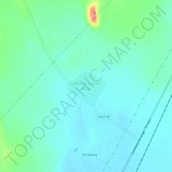
Name: General Carlos Real topographic map, elevation, terrain.
Location: General Carlos Real, Municipio de Durango, Durango, Mexico (24.26444 -104.47217 24.30444 -104.43217)
Average elevation: 1,882 m
Minimum elevation: 1,865 m
Maximum elevation: 1,955 m
Make a donation
Gear up for your next adventure:
As an Amazon Associate, this site earns from qualifying purchases at no extra cost to you.
Other topographic maps
Click on a map to view its topography, its elevation and its terrain.
Durango
Mexico > Durango > Municipio de Durango
Durango (Spanish pronunciation: [duˈɾaŋɡo], Southeastern Tepehuan: Korian), is the capital and largest city of the northern Mexican state of Durango and the seat of the Durango municipality. It has a population of 654,876 as of the 2015 census. The city's official name is Victoria de Durango, Victoria…
Average elevation: 1,936 m
Durango
Mexico > Durango > Municipio de Durango
Durango (Spanish pronunciation: [duˈɾaŋɡo], Southeastern Tepehuan: Korian) is the capital and largest city of the northern Mexican state of Durango and the seat of the Durango municipality. It has a population of 654,876 as of the 2015 census. The city's official name is Victoria de Durango, Victoria…
Average elevation: 1,936 m
Durango
Mexico > Durango > Municipio de Durango
Durango (Spanish pronunciation: [duˈɾaŋɡo], Southeastern Tepehuan: Korian) is the capital and largest city of the northern Mexican state of Durango and the seat of the municipality of Durango. It has a population of 616,068 as of the 2020 census with 688,697 living in the municipality. The city's official…
Average elevation: 1,936 m