Geolocate

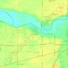
Frankton topographic map

Click on the map to display elevation.

About this map

Name: Frankton topographic map, elevation, terrain.

Location: Frankton, Madison County, Indiana, United States (40.21015 -85.78782 40.22687 -85.75757)

Average elevation: 259 m

Minimum elevation: 246 m

Maximum elevation: 267 m

Other topographic maps

Click on a map to view its topography, its elevation and its terrain.
Glyn Ellen

United States > Indiana > Madison County > Anderson

Average elevation: 271 m

Hillcrest

United States > Indiana > Madison County > Anderson

Average elevation: 269 m

Hillcrest

United States > Indiana > Madison County > Anderson

Average elevation: 269 m

Gear up for your next adventure:

🥾Trail Running Shoes - Lightweight and durable shoes for trail running
🧤Thermal Hiking Gloves - Grip-enhanced gloves for cold-weather altitude trekking
🔨Vehicle Emergency Tool - Safety tool for remote road trips to trailheads
🕶️Polarized Sunglasses - Reduces glare from snow and water at high elevations
💡Solar Camping Lamp - Eco-friendly lighting for campsites

As an Amazon Associate, this site earns from qualifying purchases at no extra cost to you.