
Pelem topographic map
Click on the map to display elevation.
About this map
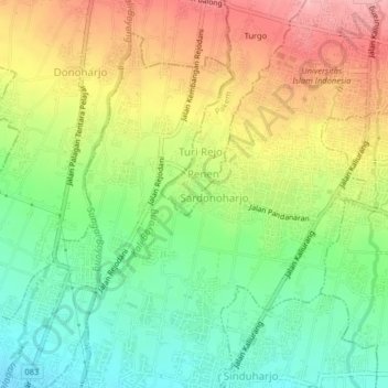
Name: Pelem topographic map, elevation, terrain.
Average elevation: 282 m
Minimum elevation: 219 m
Maximum elevation: 359 m
Other topographic maps
Click on a map to view its topography, its elevation and its terrain.
Mount Merapi National Park
Indonesia > Special Region of Yogyakarta > Sleman Regency > Hargobinangun
Average elevation: 1,150 m
Waterboom Jogja
Indonesia > Special Region of Yogyakarta > Sleman Regency > Wedomartani
Average elevation: 176 m
Wisdom park
Indonesia > Special Region of Yogyakarta > Sleman Regency > Catur tunggal
Average elevation: 136 m
Ijo Temple
Indonesia > Special Region of Yogyakarta > Sleman Regency > Sambirejo
The temple compound is located in Groyokan hamlet, Sambirejo village, Kecamatan Prambanan, Sleman Regency, Yogyakarta. The temple's name derived from its location, the Gumuk Ijo hill. The temple compound stood on western slope of the hill, in a quiet region east of Yogyakarta, around 4 kilometers southeast…
Average elevation: 233 m
Embung Tambakboyo
Indonesia > Special Region of Yogyakarta > Sleman Regency > Condongcatur > Condongcatur
Average elevation: 164 m
Donoharjo
Indonesia > Special Region of Yogyakarta > Sleman Regency > Donoharjo
Average elevation: 281 m