
Bewdley topographic map
Click on the map to display elevation.
About this map
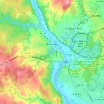
Name: Bewdley topographic map, elevation, terrain.
Location: Bewdley, Wyre Forest, Worcestershire, England, United Kingdom (52.35234 -2.36582 52.39033 -2.27733)
Average elevation: 75 m
Minimum elevation: 18 m
Maximum elevation: 176 m
Other topographic maps
Click on a map to view its topography, its elevation and its terrain.
Stourport Historic Canal Basins
United Kingdom > England > Worcestershire > Wyre Forest > Stourport-on-Severn > Wilden
Average elevation: 33 m
River Severn
United Kingdom > England > Worcestershire > Wyre Forest > Stourport-on-Severn
Average elevation: 45 m
Shatterford
United Kingdom > England > Worcestershire > Wyre Forest > Upper Arley
Average elevation: 124 m
Low Habberley
United Kingdom > England > Worcestershire > Wyre Forest > Ferndale
Average elevation: 85 m