
Make a donation
Gear up for your next adventure:
As an Amazon Associate, this site earns from qualifying purchases at no extra cost to you.
Longton topographic map
Click on the map to display elevation.
Make a donation
Gear up for your next adventure:
As an Amazon Associate, this site earns from qualifying purchases at no extra cost to you.
About this map
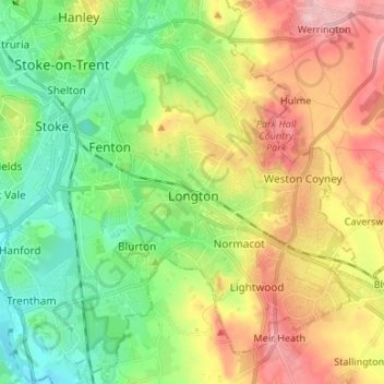
Name: Longton topographic map, elevation, terrain.
Location: Longton, Stoke-on-Trent, England, ST3 1BF, United Kingdom (52.94881 -2.17566 53.02881 -2.09566)
Average elevation: 166 m
Minimum elevation: 93 m
Maximum elevation: 273 m
Make a donation
Gear up for your next adventure:
As an Amazon Associate, this site earns from qualifying purchases at no extra cost to you.
Other topographic maps
Click on a map to view its topography, its elevation and its terrain.
Biddulph Valley Line
United Kingdom > England > Stoke-on-Trent > Hanley > Eaton Park
Average elevation: 138 m
Make a donation
Gear up for your next adventure:
As an Amazon Associate, this site earns from qualifying purchases at no extra cost to you.