
Make a donation
Gear up for your next adventure:
As an Amazon Associate, this site earns from qualifying purchases at no extra cost to you.
Hartford County topographic map
Click on the map to display elevation.
Make a donation
Gear up for your next adventure:
As an Amazon Associate, this site earns from qualifying purchases at no extra cost to you.
About this map
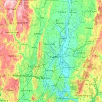
Name: Hartford County topographic map, elevation, terrain.
Average elevation: 124 m
Minimum elevation: -1 m
Maximum elevation: 435 m
Make a donation
Gear up for your next adventure:
As an Amazon Associate, this site earns from qualifying purchases at no extra cost to you.
Other topographic maps
Click on a map to view its topography, its elevation and its terrain.
West Suffield
United States > Connecticut > Capitol Planning Region > Suffield
Average elevation: 59 m
Plantsville
United States > Connecticut > Capitol Planning Region > Southington
Average elevation: 57 m
Four Corners
United States > Connecticut > Capitol Planning Region > Terramuggus
Average elevation: 143 m
Willington Hill
United States > Connecticut > Capitol Planning Region > Willington
Average elevation: 197 m
Make a donation
Gear up for your next adventure:
As an Amazon Associate, this site earns from qualifying purchases at no extra cost to you.
Griswoldville
United States > Connecticut > Capitol Planning Region > Wethersfield
Average elevation: 34 m
Make a donation
Gear up for your next adventure:
As an Amazon Associate, this site earns from qualifying purchases at no extra cost to you.
Chaffeeville
United States > Connecticut > Capitol Planning Region > Mansfield
Average elevation: 133 m
West District
United States > Connecticut > Capitol Planning Region > Farmington
Average elevation: 92 m
Talcott Mountain
United States > Connecticut > Capitol Planning Region > Bloomfield
Average elevation: 152 m
Make a donation
Gear up for your next adventure:
As an Amazon Associate, this site earns from qualifying purchases at no extra cost to you.
South Wethersfield
United States > Connecticut > Capitol Planning Region > Wethersfield > Griswoldville
Average elevation: 22 m
Buckingham
United States > Connecticut > Capitol Planning Region > Glastonbury
Average elevation: 131 m
North Coventry
United States > Connecticut > Capitol Planning Region > Coventry
Average elevation: 195 m
Make a donation
Gear up for your next adventure:
As an Amazon Associate, this site earns from qualifying purchases at no extra cost to you.
Bishop's Corner
United States > Connecticut > Capitol Planning Region > West Hartford
Average elevation: 47 m
Talcott Mountain
United States > Connecticut > Capitol Planning Region > Bloomfield
Average elevation: 152 m
Johnson Hill
United States > Connecticut > Capitol Planning Region > West Hartford
Average elevation: 34 m
Make a donation
Gear up for your next adventure:
As an Amazon Associate, this site earns from qualifying purchases at no extra cost to you.
Make a donation
Gear up for your next adventure:
As an Amazon Associate, this site earns from qualifying purchases at no extra cost to you.
Holcomb Farm
United States > Connecticut > Capitol Planning Region > Granby > West Granby
Average elevation: 116 m
Make a donation
Gear up for your next adventure:
As an Amazon Associate, this site earns from qualifying purchases at no extra cost to you.
Spoonville
United States > Connecticut > Capitol Planning Region > East Granby
Average elevation: 62 m
Stafford Springs
United States > Connecticut > Capitol Planning Region > Stafford
Average elevation: 200 m
Make a donation
Gear up for your next adventure:
As an Amazon Associate, this site earns from qualifying purchases at no extra cost to you.
Cottage Grove
United States > Connecticut > Capitol Planning Region > Bloomfield
Average elevation: 31 m
Barbara Drive
United States > Connecticut > Capitol Planning Region > Windsor Locks
Average elevation: 39 m
Make a donation
Gear up for your next adventure:
As an Amazon Associate, this site earns from qualifying purchases at no extra cost to you.