
Make a donation
Gear up for your next adventure:
As an Amazon Associate, this site earns from qualifying purchases at no extra cost to you.
Río Mondomo topographic map
Click on the map to display elevation.
Make a donation
Gear up for your next adventure:
As an Amazon Associate, this site earns from qualifying purchases at no extra cost to you.
About this map
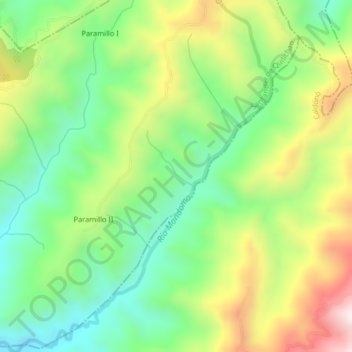
Name: Río Mondomo topographic map, elevation, terrain.
Location: Río Mondomo, Caldonó, Norte, Cauca, RAP Pacífico, Colombia (2.88964 -76.40846 2.93030 -76.37676)
Average elevation: 2,129 m
Minimum elevation: 1,850 m
Maximum elevation: 2,566 m
Make a donation
Gear up for your next adventure:
As an Amazon Associate, this site earns from qualifying purchases at no extra cost to you.
Other topographic maps
Click on a map to view its topography, its elevation and its terrain.
Subestación Eléctrica Pescador (Cauca)
Colombia > Cauca > Caldonó > El Mango
Average elevation: 1,523 m
Make a donation
Gear up for your next adventure:
As an Amazon Associate, this site earns from qualifying purchases at no extra cost to you.
Subestación Eléctrica Pescador (Cauca)
Colombia > Cauca > Caldonó > Resguardo Indígena la María
Average elevation: 1,523 m