
Make a donation
Gear up for your next adventure:
As an Amazon Associate, this site earns from qualifying purchases at no extra cost to you.
Humboldt Hill topographic map
Click on the map to display elevation.
Make a donation
Gear up for your next adventure:
As an Amazon Associate, this site earns from qualifying purchases at no extra cost to you.
Humboldt Hill
Humboldt Hill is a census-designated place (CDP) in Humboldt County, California, United States. Humboldt Hill rises to an elevation of 636 feet (194 m). The population was 3,414 at the 2010 census, up from 3,246 at the 2000 census. The area is in the 95503 zip code and part of unincorporated Eureka.
Make a donation
Gear up for your next adventure:
As an Amazon Associate, this site earns from qualifying purchases at no extra cost to you.
About this map
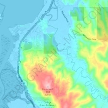
Name: Humboldt Hill topographic map, elevation, terrain.
Location: Humboldt Hill, Humboldt County, California, United States (40.69698 -124.21557 40.75559 -124.17696)
Average elevation: 45 m
Minimum elevation: -6 m
Maximum elevation: 210 m
Make a donation
Gear up for your next adventure:
As an Amazon Associate, this site earns from qualifying purchases at no extra cost to you.
Other topographic maps
Click on a map to view its topography, its elevation and its terrain.
Make a donation
Gear up for your next adventure:
As an Amazon Associate, this site earns from qualifying purchases at no extra cost to you.
South Fork Elk River
United States > California > Humboldt County > Pine Hills
Average elevation: 70 m
Make a donation
Gear up for your next adventure:
As an Amazon Associate, this site earns from qualifying purchases at no extra cost to you.
Make a donation
Gear up for your next adventure:
As an Amazon Associate, this site earns from qualifying purchases at no extra cost to you.
Make a donation
Gear up for your next adventure:
As an Amazon Associate, this site earns from qualifying purchases at no extra cost to you.
Make a donation
Gear up for your next adventure:
As an Amazon Associate, this site earns from qualifying purchases at no extra cost to you.
Make a donation
Gear up for your next adventure:
As an Amazon Associate, this site earns from qualifying purchases at no extra cost to you.
Make a donation
Gear up for your next adventure:
As an Amazon Associate, this site earns from qualifying purchases at no extra cost to you.
Weitchpec
United States > California > Humboldt County
Weitchpec (/ˈwɛtʃpɛk/ WETCH-pek (Karuk: ansáfriik, Yurok: Wechpues, Wech,) is an unincorporated community within the Yurok reservation in Humboldt County, California, United States. It is located 35 miles (56 km) northeast of Eureka, at an elevation of 361 feet (110 m). The ZIP Code is 95546.
Average elevation: 354 m
Make a donation
Gear up for your next adventure:
As an Amazon Associate, this site earns from qualifying purchases at no extra cost to you.
Hydesville
United States > California > Humboldt County
Hydesville is a census-designated place (CDP) in Humboldt County, California, United States. Hydesville is located 4.5 miles (7.2 km) southeast of Fortuna, at an elevation of 364 feet (111 m). The population was 1,237 at the 2010 census, up from 1,209 at the 2000 census.
Average elevation: 162 m
Make a donation
Gear up for your next adventure:
As an Amazon Associate, this site earns from qualifying purchases at no extra cost to you.
Blue Lake
United States > California > Humboldt County
Blue Lake (formerly, Scottsville) is a city in Humboldt County, California, United States. Blue Lake is located on the Mad River in a deep valley, 16 miles (26 km) northeast of Eureka, at an elevation of 131 feet (40 m). Its population is 1,208 as of the 2020 census, down from 1,253 from the 2010 census.
Average elevation: 74 m
Make a donation
Gear up for your next adventure:
As an Amazon Associate, this site earns from qualifying purchases at no extra cost to you.
Make a donation
Gear up for your next adventure:
As an Amazon Associate, this site earns from qualifying purchases at no extra cost to you.
Redway
United States > California > Humboldt County
Redway is a census-designated place (CDP) in Humboldt County, California, United States. Redway is located 2.25 miles (3.6 km) northwest of Garberville, at an elevation of 538 feet (164 m). The population was 1,225 at the 2010 census, up from 1,188 at the 2000 census. Redway is also home to Redway Elementary…
Average elevation: 176 m
Rio Dell
United States > California > Humboldt County
Rio Dell (Spanish: Río Dell, meaning "Dell River") is a city in Humboldt County, California, United States. It is located on the west bank of the Eel River 1 mile (2 km) north of Scotia at an elevation of 161 feet (49 m). The population was 3,363 at the 2010 census, up from 3,174 at the 2000 census.
Average elevation: 97 m
Make a donation
Gear up for your next adventure:
As an Amazon Associate, this site earns from qualifying purchases at no extra cost to you.
Harry A. Merlo State Recreational Area
United States > California > Humboldt County > Big Lagoon Rancheria
Average elevation: 33 m
Make a donation
Gear up for your next adventure:
As an Amazon Associate, this site earns from qualifying purchases at no extra cost to you.
Orick
United States > California > Humboldt County
Orick (formerly, Arekw, Orekw, and Oreq, Yurok: 'O'rekw ) is a census-designated place situated on the banks of the Redwood Creek in Humboldt County, California. It is located 43 miles (69 km) north of Eureka, at an elevation of 26 feet (8 m). The population was 357 at the 2010 census.
Average elevation: 125 m
Make a donation
Gear up for your next adventure:
As an Amazon Associate, this site earns from qualifying purchases at no extra cost to you.
Trinidad
United States > California > Humboldt County
Trinidad (Spanish for "Trinity"; Yurok: Chuerey) is a seaside city in Humboldt County, located on the Pacific Ocean 8 miles (13 km) north of the Arcata-Eureka Airport and 15 miles (24 km) north of the college town of Arcata. Trinidad is noted for its coastline with ten public beaches and offshore rocks, part…
Average elevation: 38 m
Redwood Forest - Backyards
United States > California > Humboldt County > Eureka
Average elevation: 29 m
Make a donation
Gear up for your next adventure:
As an Amazon Associate, this site earns from qualifying purchases at no extra cost to you.