Geolocate

Floridablanca topographic map

Click on the map to display elevation.

About this map

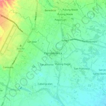
Name: Floridablanca topographic map, elevation, terrain.

Location: Floridablanca, Pampanga, Central Luzon, 2006, Philippines (14.93598 120.48870 15.01598 120.56870)

Average elevation: 24 m

Minimum elevation: 5 m

Maximum elevation: 79 m

Other topographic maps

Click on a map to view its topography, its elevation and its terrain.

Angeles

Philippines > Pampanga

Sapangbato is the largest barangay in Angeles in terms of territory, with a total land area of 104,694 sq. meters and a population of 11,262. Located northwest of Angeles near Clark Freeport Zone, it is identified as the barangay in Angeles with the highest elevation of 750 feet above sea level. It is home to…

Average elevation: 98 m

Paligui

Philippines > Pampanga > Candaba

Average elevation: 8 m

Magalang

Philippines > Pampanga

Average elevation: 69 m

San Simon

Philippines > Pampanga

Average elevation: 5 m

Mabalacat

Philippines > Pampanga

Average elevation: 117 m

Gear up for your next adventure:

🔦LED Flashlight - Powerful and long-lasting flashlight for camping and emergencies
👖Convertible Hiking Pants - Zip-off legs to adapt to changing weather conditions
🦌Outdoor Trail Camera - Monitor wildlife activity near your favorite spots
🕶️Polarized Sunglasses - Protect your eyes with durable polarized lenses
🧴Bear Spray Holster - Quick-access carry for essential Canadian wilderness safety

As an Amazon Associate, this site earns from qualifying purchases at no extra cost to you.