
Make a donation
Gear up for your next adventure:
As an Amazon Associate, this site earns from qualifying purchases at no extra cost to you.
Hampstead topographic map
Click on the map to display elevation.
Make a donation
Gear up for your next adventure:
As an Amazon Associate, this site earns from qualifying purchases at no extra cost to you.
Hampstead
The Town of Hampstead was founded in 1914. It was designed to be an exclusive garden city. There are no retail shops within municipal boundaries. Houses were assigned relatively large lots to allow space for trees and shrubbery. The town's roads were designed with curves in order to slow down traffic and to create an interesting and intimate landscape. Despite its rather flat topography—much of the territory was once a golf course—the town was named after another garden city, the London suburb of Hampstead Village. Like its namesake, Hampstead is the home of many affluent citizens, and competes with a few other suburbs for first place in the rankings of highest average household incomes in Canada.
Make a donation
Gear up for your next adventure:
As an Amazon Associate, this site earns from qualifying purchases at no extra cost to you.
About this map
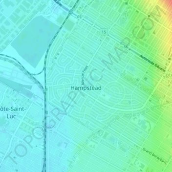
Name: Hampstead topographic map, elevation, terrain.
Average elevation: 57 m
Minimum elevation: 47 m
Maximum elevation: 95 m
Urban agglomeration of Montreal trails, hiking, mountain biking, running and outdoor activities
Make a donation
Gear up for your next adventure:
As an Amazon Associate, this site earns from qualifying purchases at no extra cost to you.
Other topographic maps
Click on a map to view its topography, its elevation and its terrain.
Mount Royal
Canada > Quebec > Urban agglomeration of Montreal > Montreal
The hill is part of the Monteregian Hills situated between the Laurentians and the Appalachian Mountains. It gave its Latin name, Mons Regius, to the Monteregian chain. The hill consists of three peaks: Colline de la Croix (or Mont Royal proper) at 233 m (764 ft), Colline d'Outremont (or Mount Murray, in the…
Average elevation: 111 m
Parc Léon-Provancher
Canada > Quebec > Urban agglomeration of Montreal > Montreal
Average elevation: 53 m
Make a donation
Gear up for your next adventure:
As an Amazon Associate, this site earns from qualifying purchases at no extra cost to you.
Saint Helen's Island
Canada > Quebec > Urban agglomeration of Montreal > Montreal
Average elevation: 15 m
Parc-nature du Bois-de-Liesse
Canada > Quebec > Urban agglomeration of Montreal > Montreal
Average elevation: 28 m
Banc de Châteauguay
Canada > Quebec > Urban agglomeration of Montreal > Dorval
Average elevation: 20 m
Make a donation
Gear up for your next adventure:
As an Amazon Associate, this site earns from qualifying purchases at no extra cost to you.
Mount Royal Park
Canada > Quebec > Urban agglomeration of Montreal > Montreal
The mountain is part of the Monteregian Hills situated between the Laurentians and the Appalachian Mountains. It gave its Latin name, Mons Regius, to the Monteregian chain. The mountain consists of three peaks: Colline de la Croix (or Mont Royal proper) at 233 m (764 ft), Colline d'Outremont (or Mount Murray,…
Average elevation: 110 m
Cap Saint-Jacques
Canada > Quebec > Urban agglomeration of Montreal > Montreal
Average elevation: 25 m
Make a donation
Gear up for your next adventure:
As an Amazon Associate, this site earns from qualifying purchases at no extra cost to you.
Mount Royal
Canada > Quebec > Urban agglomeration of Montreal > Montreal
The mountain is part of the Monteregian Hills situated between the Laurentians and the Appalachian Mountains. It gave its Latin name, Mons Regius, to the Monteregian chain. The mountain consists of three peaks: Colline de la Croix (or Mont Royal proper) at 233 m (764 ft), Colline d'Outremont (or Mount Murray,…
Average elevation: 111 m
Make a donation
Gear up for your next adventure:
As an Amazon Associate, this site earns from qualifying purchases at no extra cost to you.
Colline de l'Abri
Canada > Quebec > Urban agglomeration of Montreal > Montreal
Average elevation: 120 m