Geolocate

Lower Olave topographic map

Click on the map to display elevation.

About this map
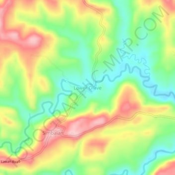
Name: Lower Olave topographic map, elevation, terrain.

Location: Lower Olave, Agusan del Norte, Caraga, Philippines (8.80651 125.42629 8.84651 125.46629)

Average elevation: 125 m

Minimum elevation: 37 m

Maximum elevation: 232 m

Other topographic maps

Click on a map to view its topography, its elevation and its terrain.

Kitcharao

Philippines > Agusan del Norte

Average elevation: 293 m

Las Nieves

Philippines > Agusan del Norte

Average elevation: 113 m

Cabadbaran River

Philippines > Agusan del Norte

Average elevation: 722 m

Las Nieves

Philippines > Agusan del Norte

Average elevation: 113 m

Las Nieves

Philippines > Agusan del Norte

Average elevation: 113 m

Gear up for your next adventure:

🔦LED Headlamp - Hands-free lighting for early morning starts or late finishes
🦶Hiking Shoe Insoles - Added support for high arches and long days on feet
🧭GPS Outdoor Watch - Smart watch for navigation and fitness tracking in nature
🛶Waterproof Dry Bags - Keep electronics and clothes dry during river crossings
🧤Rechargeable Heated Gloves - Extreme warmth for Canadian winter expeditions

As an Amazon Associate, this site earns from qualifying purchases at no extra cost to you.