
Make a donation
Gear up for your next adventure:
As an Amazon Associate, this site earns from qualifying purchases at no extra cost to you.
Kitcharao topographic map
Click on the map to display elevation.
Make a donation
Gear up for your next adventure:
As an Amazon Associate, this site earns from qualifying purchases at no extra cost to you.
About this map
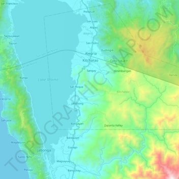
Name: Kitcharao topographic map, elevation, terrain.
Location: Kitcharao, Agusan del Norte, Caraga, 8609, Philippines (9.36824 125.52051 9.46838 125.74906)
Average elevation: 293 m
Minimum elevation: 0 m
Maximum elevation: 1,723 m
Make a donation
Gear up for your next adventure:
As an Amazon Associate, this site earns from qualifying purchases at no extra cost to you.
Other topographic maps
Click on a map to view its topography, its elevation and its terrain.
Cabadbaran
Philippines > Agusan del Norte
It is 29 kilometres (18 mi) from Butuan. It is generally flat with rolling hills and swamplands in its western part. The highest of all mountains in the Caraga region, Mount Hilong-Hilong (with an altitude of 2,012 metres (6,601 ft) above sea level), rises in this city.
Average elevation: 179 m
Make a donation
Gear up for your next adventure:
As an Amazon Associate, this site earns from qualifying purchases at no extra cost to you.
Jabonga
Philippines > Agusan del Norte
The topography of the land features plain to rolling and hills. Among the municipalities, Jabonga ranks first in total area and number of farms (464) mostly owned by individuals. It has one of the 36 crop storage facilities of the province. Its major crops are coconut, rice, corn, timber and both fresh and…
Average elevation: 116 m
Make a donation
Gear up for your next adventure:
As an Amazon Associate, this site earns from qualifying purchases at no extra cost to you.
Make a donation
Gear up for your next adventure:
As an Amazon Associate, this site earns from qualifying purchases at no extra cost to you.
Make a donation
Gear up for your next adventure:
As an Amazon Associate, this site earns from qualifying purchases at no extra cost to you.
Make a donation
Gear up for your next adventure:
As an Amazon Associate, this site earns from qualifying purchases at no extra cost to you.
Make a donation
Gear up for your next adventure:
As an Amazon Associate, this site earns from qualifying purchases at no extra cost to you.
Make a donation
Gear up for your next adventure:
As an Amazon Associate, this site earns from qualifying purchases at no extra cost to you.
Make a donation
Gear up for your next adventure:
As an Amazon Associate, this site earns from qualifying purchases at no extra cost to you.
Cabadbaran
Philippines > Agusan del Norte
It is generally flat with rolling hills and swamplands in its western part. The highest of all mountains in the Caraga region, Mount Hilong-Hilong (with an altitude of 2,012 metres (6,601 ft) above sea level), rises in this city.
Average elevation: 179 m
Make a donation
Gear up for your next adventure:
As an Amazon Associate, this site earns from qualifying purchases at no extra cost to you.
Magallanes
Philippines > Agusan del Norte
The topography of the land is mostly flat and rolling, surrounded by mountains. Swamps characterize much of the landscape that is situated at the mouth of the two major rivers in the province, the Agusan and Baug Rivers.
Average elevation: 3 m
Make a donation
Gear up for your next adventure:
As an Amazon Associate, this site earns from qualifying purchases at no extra cost to you.
Jabonga
Philippines > Agusan del Norte
The topography of the land features plain to rolling and hills. Among the municipalities, Jabonga ranks first in total area and number of farms (464) mostly owned by individuals. It has one of the 36 crop storage facilities of the province. Its major crops are coconut, rice, corn, timber and both fresh and…
Average elevation: 116 m