Geolocate

Terrer topographic map

Click on the map to display elevation.

About this map

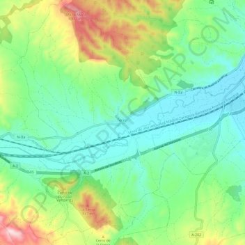
Name: Terrer topographic map, elevation, terrain.

Location: Terrer, Comunidad de Calatayud, Zaragoza, Aragon, Spain (41.28249 -1.76233 41.37012 -1.69078)

Average elevation: 650 m

Minimum elevation: 529 m

Maximum elevation: 936 m

Other topographic maps

Click on a map to view its topography, its elevation and its terrain.

Solana

Spain > Aragon > Comunidad de Calatayud > Calatayud

Average elevation: 874 m

Pico Agudo

Spain > Aragon > Comunidad de Calatayud > Codos

Average elevation: 963 m

Valderoy

Spain > Aragon > Comunidad de Calatayud > Ateca

Average elevation: 659 m

Gear up for your next adventure:

❄️Traction Ice Cleats - Slip-on spikes for icy trails and winter hiking
🛌Down Sleeping Bag - Superior warmth-to-weight ratio for cold nights
🕶️Polarized Sunglasses - Protect your eyes with durable polarized lenses
💧Filtered Water Bottle - Safe drinking water on the go
👟Leg Gaiters - Keep debris, mud, and snow out of your boots

As an Amazon Associate, this site earns from qualifying purchases at no extra cost to you.