Geolocate

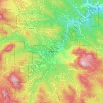
Evergreen topographic map

Click on the map to display elevation.

Evergreen

Evergreen sits at an elevation of 7,220 feet (2,200 m) in the Rocky Mountains, 19 miles west of Denver, Colorado.

Wikipedia (CC-BY-SA 3.0)

About this map

Name: Evergreen topographic map, elevation, terrain.

Location: Evergreen, Jefferson County, Colorado, 80457, United States (39.59285 -105.36330 39.67285 -105.28330)

Average elevation: 2,301 m

Minimum elevation: 2,027 m

Maximum elevation: 2,621 m

Other topographic maps

Click on a map to view its topography, its elevation and its terrain.

Applewood

United States > Colorado > Jefferson County > Applewood

Average elevation: 1,738 m

Arvada

United States > Colorado > Jefferson County

Average elevation: 1,665 m

Gear up for your next adventure:

🧦Crew Hiking Socks - Comfortable socks for long-distance hikes
👖Convertible Hiking Pants - Zip-off legs to adapt to changing weather conditions
🧤Insulated Winter Gloves - Heavy-duty protection for sub-zero Canadian adventures
🧢Outdoor Cap - Protective cap for sun and rain during hikes
👟Trail Running Shoes - Agile footwear for fast-paced topographic exploration

As an Amazon Associate, this site earns from qualifying purchases at no extra cost to you.