Geolocate

Mayangone topographic map

Click on the map to display elevation.

About this map

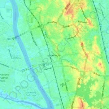
Name: Mayangone topographic map, elevation, terrain.

Location: Mayangone, Mayangon District, Yangon City, Yangon, Myanmar (16.82491 96.09468 16.90806 96.17849)

Average elevation: 12 m

Minimum elevation: -3 m

Maximum elevation: 37 m

Other topographic maps

Click on a map to view its topography, its elevation and its terrain.

Zee Kone

Myanmar > Yangon > Yangon City

Average elevation: 11 m

Htauk Kyant

Myanmar > Yangon > Yangon City

Average elevation: 17 m

Gear up for your next adventure:

Camping Groundsheet - Protect your tent from moisture and dirt
🔭Outdoor Binoculars - Lightweight binoculars for birdwatching and hiking
🔦LED Headlamp - Hands-free lighting for early morning starts or late finishes
🔋Solar Power Bank - Keep your GPS and devices charged during long outdoor trips
🦌Outdoor Trail Camera - Monitor wildlife activity near your favorite spots

As an Amazon Associate, this site earns from qualifying purchases at no extra cost to you.