Geolocate

Wrightstown topographic map

Click on the map to display elevation.

About this map

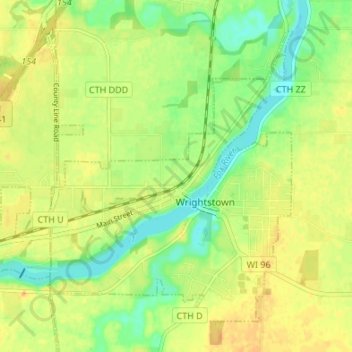
Name: Wrightstown topographic map, elevation, terrain.

Location: Wrightstown, Brown County, Wisconsin, 54180, United States (44.30976 -88.21341 44.34951 -88.14605)

Average elevation: 199 m

Minimum elevation: 181 m

Maximum elevation: 214 m

Other topographic maps

Click on a map to view its topography, its elevation and its terrain.

Greenleaf

United States > Wisconsin > Brown County

Average elevation: 226 m

Anston

United States > Wisconsin > Brown County

Average elevation: 225 m

Champion

United States > Wisconsin > Brown County

Average elevation: 235 m

New Franken

United States > Wisconsin > Brown County

Average elevation: 244 m

Bellevue

United States > Wisconsin > Brown County > Bellevue > Bellevue

Average elevation: 211 m

Holland

United States > Wisconsin > Brown County

Average elevation: 235 m

Gear up for your next adventure:

🧥Thermal Fleece Jacket - Versatile insulation for changing mountain temperatures
🔋Emergency Crank Radio - Weather alerts and power without needing batteries
🥾Hiking Boots - Sturdy boots providing ankle support and traction on rugged trails
🧢Sun Hat - Wide-brim hat for sun protection
🛶Waterproof Dry Bags - Keep electronics and clothes dry during river crossings

As an Amazon Associate, this site earns from qualifying purchases at no extra cost to you.